
Report for Afognak Native Corporation,
Native Village of Afognak, and
United States Bureau of Indian Affairs
In compliance with BIA/ARPA Permits No. 1999-2 & 2000-1
Donald W. Clark
15 Ellery Crescent, Nepean, Ontario
K2H 6M5
August 2000
Prepared at Kodiak, Alaska, for the Native village of Afognak
CONTENTS
Abstract
Preface ………………………………………….…………………..........………… 1
Introduction
Background …………………………………………..……………….......... 2
The People the Russians Met …………………………………..…..... 5
Links to the Historic Alutiiq of Afognak ………………………...… 6
The Aleut Town Site
Site Description …………………………………………..........…………… 7
Excavations ……………………………………………………….........….. 10
Soils and Stratigraphy ……………………………………………......… 15
Features
North House ………………………………………………...........….. 16
South House ………………………………………………..........…... 34
Stone slab-lined pit ……………………………………….........…… 35
Burial ……………………………………………………................……. 35
Solitary and grouped stone slabs ……………………………... 36
Pea gravel floor ……………………………………...........…………. 37
Petroglyphs ………………………………………………............…... 37
Collections
Indigenous -Type Artifacts ………………………………………....… 38
Artifact Notes and Comparisons
Comparison with Crag Point ………………………………....… 48
Further descriptive notes and comments ……………….. 53
Culture Placement and Dating through Comparisons
Postcontact Period ………………………………………………….… 59
Precontact Period ……………………………………………….….…. 62
Discussion
Survival of the Archaeological Record …………………………… 63
The Kachemak Tradition Mode of Culture
and Technology ……................................................…... 64
The Missing Russian and Koniag
Tradition Occupations …………....................................... 66
A Lesson from the Pits ………………………………….....…………… 68
References …………………………………………………………......…………. 69
Plates …………………………………………………………………….........……. 72
ABSTRACT
In 1999 the Native Village of Afognak engaged the Afognak Native Corporation to test an archaeological midden site located at the old Afognak Village on Afognak Island, Kodiak Archipelago. The project was continued for a second season in 2000. This work was done with US Bureau of Indian Affairs support to mitigate the proposed sale of land upon which the site is situated. In 1999 the excavation consisted of a 4 by 5-meter block dug to the base of cultural deposits. In 2000 an additional 20 square meters was excavated. Dr. D.W Clark was the archaeologist in charge in both seasons. Logistical support, staff and equipment were provided through ANC's and NVA's Dig Afognak program and the ANC and NVA staff in Kodiak.
Approximately 500 historic artifacts (400 catalog lots) were collected from above the 1912 Katmai ash and from the upper part of the underlying soil in 1999. In 2000 an additional 2500 historic artifacts were found. These are mainly ceramic sherds, nails, bottle glass window (flat) glass and parts of cast iron stoves. Houses on the site became abandoned progressively during the 20th century; the last one was vacated about 1961. Relatively few items, two .44 Henry cartridge cases and a few painted ceramic sherds for instance, represent the early American period, before about 1900, for instance. The Russian period, before 1868, possibly is not represented at all. There are approximately 800 indigenous artifacts from precontact levels, half from each season, predating the end of the 18th century. Some come from mixed historic/precontact deposits that had been disturbed by later construction and "landscaping." Remains from the ancestral Alutiiq Koniag tradition (dating after about 1200 AD) are very sparse. Almost the entire precontact occupation was by people of the Late Kachemak tradition, which predated AD 1200. Bone preservation was good. This resulted in the recovery of numerous harpoon heads and other bone implements.
Two Kachemak houses had been dug to the base of the site, though an underlying loam to beach gravel. The combined 1999-2000 projects uncovered an estimated three-quarters of a North House floor with hearth and considerable less of a South House floor, both of which extended outside the limits of excavation. On the floors there were almost no implements and trash other than ulu blades. This shows a high standard of house keeping and neatness in ancient times.
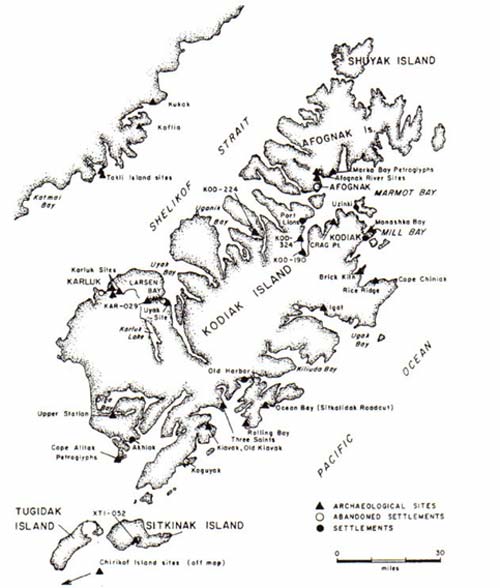
Figure 1. Map of the Kodiak Archipelago showing excavated sites. (From Clark 1992; prepared before excavations were done at Tanginak Anchorage, Buskin River, Zaimka and Aleut Village.).
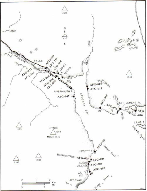
Figure 2. Afognak Bay area map showing the location of archaeological sites (Updated from Clark 1979).
PREFACE
This report describes an archaeological excavation done in 1999 and 2000 at the Aleut Town site at Afognak. The Afognak Native Corporation administered the project for the Native Village of Afognak. The Dig Afognak program provided logistical organization and support. Dr. Donald W. Clark was hired as lead archaeologist for the term of the fieldwork.
Excavation was done during the period June 1 through July 23 in 1999 and June 13 through July 26, 2000 inclusive of a day of rest each week and midseason breaks when Dig Afognak staff and the excavators returned to Kodiak. Altogether, 28 days were spent on the site each year. Unlike the disconcerting and discomforting situation in 1999, only one workday was lost due to weather (wind) in 2000. Working conditions at the site were enhanced in 2000 through erecting a large Weatherport shelter over the excavation. Through lab time, including evening sessions, it was possible to clean, dry and catalog most the collection in the field at the Katenai base (faunal remains cleaned and dried only). Part of the lab work, including the inventory of historic material from the upper levels, also was done in Kodiak during the midseason break.
One dedicated assistant, C. Rose Ward assisted the lead archaeologist. Dig Afognak also freed camp assistant Michael Abate to work at the excavation, and, on some days in 2000 camp assistant Yorgen Haakanson. Camp manager Sven Haakanson, Jr., assisted with excavations and erection of the weatherport shelter. Andrew Christopherson transported the crew each day and assisted with other logistics in 1999 and during the first half of the season, as did Sherise Relyea, who also excavated for several days, during the second half of the season. Patrick G. Saltonstall at the Alutiiq Museum significantly assisted in the production of illustrations for the present report and also assisted the excavation while he was a guest scientist at Katenai in 2000. Amy Steffian prepared the final versions of six figures. ANC and NVA staff in Kodiak took care of numerous logistical details and reproduction of the present report. The last day was spent in backfilling the excavation. Returning the rock and soil to the pit whence it had been excavated laboriously by trowel and buckets was a concerted effort by all camp staff, elders, infants and instructors and students of the Academy of Elders Science camp, Teri Schneider director.
The site of excavation officially is designated as 49-AFO-004. It is customary to name archaeological sites, and some carry the name they had when they were living settlements. For nearly a century the locality excavated has been part of Aleut Town (local usage) or Aleut Village in published cartography. Accordingly, and with the concurrence of the Afognak Native Corporation, we selected Aleut Town for the site name. Recently in June 2000 we learned that the site also had been part of the early historic Alutiiq village Naschkuchalik (Langsdorff 1812; personal comm. from Afognak elders June 2000).
Previous archaeological work at Afognak Bay includes surveys by Clark in1951 and by Clark and Workman in 1964 (Clark 1970, Workman and Clark 1979). In 1971 D. Clark and William Workman, from the Canadian Museum of Civilization and Alaska Methodist University, respectively, excavated two sites of he earliest known people in the region, the Ocean Bay culture, located at the mouth of the Afognak River (Clark 1979).
Patrick Saltonstall excavated an ancestral Alutiiq (Koniag tradition) village located at Settlement Point during the years 1994-997 as part of the Afognak Native Corporation's Dig Afognak program (Saltonstall 1997). In the same program in 1994-1998 Katharine Woodhouse-Beyer excavated a major portion of the historic artel and village Kaataq, also located near Settlement Point Kataaq or Katenai erroneously was identified as Igvetsk in the 1999 report. Afognak elders recently informed the writer that Igwik or Igvetsk is Little Afognak. At that time D.Clark also made minor investigations at the mouth of the Afognak River (Clark 1997). In 1997 Woodhouse-Beyer excavated a 1-meter-square test pit close to the edge of the bank at Aleut Town. The Aleut Town excavations described in 1999 and in the present report followed this. Elsewhere on Afognak Island excavation sponsored by the Afognak Native Corporation has been done at Malina Creek (Malina Beach) and by the State of Alaska on Shuyak Island. Clark (1992) summarizes archaeological research on Kodiak as also does Knecht (1995).
INTRODUCTION
BACKGROUND
Afognak has been the home of populous Eskimoan maritime hunters for at last 7500 years (Clark 1994). Their ancient villages were located in every bay and at the mouth of every important salmon stream. The long well-stocked littoral (shore) zone and surrounding waters provided for a large population that numbered approximately 8000 persons on Kodiak and Afognak at the time of Russian contact in the 1760s.
This rich oceanic setting includes fishing banks located east of Afognak, seal and sea lion rookeries and haulouts, bird rookeries, migratory populations of whales and fur seals and a bountiful littoral zone exposed by tides that range up to13 feet between highs and lows. Virtually everything from whales to periwinkles occurs in an extended distribution along the complexly embayed coastline. But sometimes-prolonged stormy periods made it difficult to hunt and fish, and the seasons were not equally bountiful.
Though there was a degree of cultural continuity through 7500 years (based on a dated site located at the head of Afognak Bay and somewhat older sites at Chiniak Bay excavated by Saltonstall and Steffian and equally old sites elsewhere on Kodiak), this duration was punctuated by numerous technological developments. For instance, the invention of the technique of grinding tools from slate instead of flaking them from hard flinty stone. Over time technological and stylistic changes lead to the phasing of precontact history through a series of periods or traditions: Ocean Bay, Kachemak and Koniag. Koniag is ancestral Alutiiq. To some degree there was continuity of population and culture from the earlier periods to recent times. Thus at 1200 AD Kachemak was at
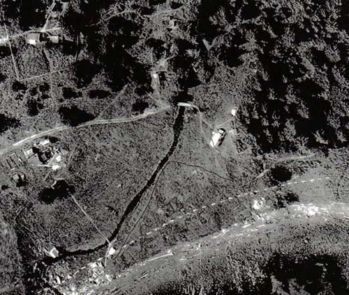
Figure 3. The Aleut Town site from 1964 air photograph. The current shore edge is marked.
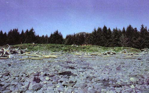
Figure 4. Site AFG-004 from the shore showing the partially healed erosion face.
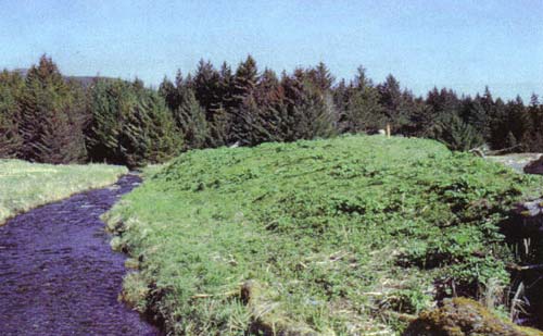
Figure 5. The back of the site along the creek, looking NNW. From this angle the Aleut Town site is a distinct though natural mound that slopes rapidly to the creek.
least in part ancestral Koniag, and, in turn, Kachemak appears to have developed out of Ocean Bay about 1800 BC. That raises the debated question of what language was spoken on Kodiak 7000 years ago and were the people there ancestors of Eskimos.
The physical setting was not always like it appears today. Coastlines and bays have changed gradually due to erosion and earthquakes. The spruce forest did not appear on Afognak until 800 years ago or even more recently. Prior to European contact and the introduction of steel axes and saws, the primary source of timber for construction was driftwood brought in by winds and ocean currents. It was conveniently barked and trimmed through battering in the surf. The accumulated supply of driftwood likely was exhausted within a generation after initial settlement of the area and new driftwood would be claimed soon after it appeared on nearby beaches. Major timbers were salvaged and recycled when a dwelling was rebuilt. Many of the animals now found on Afognak were introduced early in the 20th century. Introductions include elk, deer, beaver, and red squirrels, hare marten and muskrat. The last three are seldom seen there today. Ground squirrels, formerly abundant on Marmot Island, apparently have been extirpated. Indigenous mammals are mainly brown bear, foxes, river otters, weasels, voles and a suite of sea mammals.
THE PEOPLE THE RUSSIANS MET
Russian fur seekers first met the inhabitants of Afognak in the 1780s. Records recount dealings of Shelikhov with Afognak Islanders. A village or house is shown near the location of Afognak Village on a 1786 map (Black 1992). Sometime before 1802 an artel had been established at Igvetsk (Little Afognak) which is a considerable distance around Marmot Bay from Afognak village. At an undetermined date early in the 19th century Kattak (Quatq, spelled Qat'at by linguist Leer; Katenai means "at Kattak") also was set up as an artel at Settlement Point a short distance across the bay from old Afognak. Concurrently, by 1802 if not by 1786 (date of map with house or zhilsche), there was a one-man post or odinochka at the site of Afognak village (Davydov 1977). Excavations in 1999 and 2000 were directed towards investigating indigenous Alutiiq use of the northeast end of the old Village, an area usually referred to as "Aleut Town" as its inhabitants were Alutiiq. This area is identified by Afognak elders (in 2000) as the location of Naschkuchlik, a village of 105 persons and 99 persons in 1795 and 1804 respectively (Langsdorff 1812:30). The Kodiaks, Native Americans, Koniags or Kadiak Aleuts, now called Alutiiq, lived by, with and from the sea. Whale hunting was important. In season whales are numerous around Marmot Bay. Whales died and drifted ashore after they were struck with poison-tipped spears (Heizer 1943). The deep bays around Afognak, like Danger Bay and Kizhuyak Bay were especially suited for the Alutiiq method of whaling as wounded whales were less likely to drift out to sea. Harbor seals, supplemented by porpoise and sea lions, which also are abundant in Marmot Bay, supplied most of the rest of red meat and oil and hides. But porpoise remains are enigmatically scarce in the Aleut Town midden. Seals were harpooned from kayaks or at shore haul-outs after being attracted within range by a decoy. Seals also were entangled in large nets and were clubbed at haul-outs like the rocks near Alexander Island. Bears were hunted with bow and arrows, though not many were killed. Occasionally there may have been trips across Shelikof Strait to the Alaska Peninsula for caribou. Sea birds were taken in nets and with a variety of multi-pronged spears. Eggs were collected at rookeries and stored for later use.
In the ocean fish obligingly attached themselves to hooked lines, especially cod, rockfish (sculpin) and halibut. Of equal importance was the summertime focus on the salmon fishery at the mouth of the Afognak River. During peak years red salmon began to arrive by the end of April, other species later. In recent years, the Afognak River run of red and silver salmon has been in the order of 100,000 fish (many pink salmon spawn below the weir, thus are not counted). But as recently as 1900 nearly 40 Alutiiq families spent the summer at Letnik fishing (officially spelled "Litnik"). It is evident too, from the shell midden deposited at the Aleut Town site and from shells littering local beaches, that clams, particularly butter clams and blue mussels, are abundant along local shores, and that they were exploited accordingly. Timing and location of the food quest followed the natural cycle of mammal and fish movements. The site of Afognak Village is characteristic of main or winter villages. It is located close to the outer bay, near resource areas and way from the isolated, sometimes frozen, heads of bays.
LINKS TO THE HISTORIC ALUTIIQ OF AFOGNAK
A critical problem is to tie together or link the historic Alutiiq inhabitants of Afognak Village to the people first encountered on Afognak by the Russians and to the precontact occupants of Aleut Town. No contact period sites occupied in the late 1700s have been identified physically though there is the 1795 census record of Naschkuchalik noted earlier. The Settlement Point site at Katenai excavated by Saltonstall was abandoned well before European contact, while the nearby Katenai artel was established sometime after the Russians had arrived. No evidence of contact period occupation was found in test pits at the Driftwood Beach (Collector Beach) site, a short distance outside Settlement Point, dug in1999 by D. Clark and G. Carver and earlier by R. Knecht and P.G. Saltonstall. That site was the location of garden plots of the later inhabitants of Katenai. As well, a site located close to Back Bay inside Afognak Bay that was tested in 1996 by Partlow and Saltonstall and earlier by Clark also is wholly precontact in age. Failure to find substantive late-precontact Koniag occupation at Aleut Town is disconcerting, but the failure also to find evidence of Russian period (1786-1867) contacts in the upper levels of the site is alarming. The site may have been modified and physically truncated by landscaping or by erosion. The unlikely alternative is that other sites in the vicinity of Aleut Town will fill this hiatus. One of these sites consisted of shallow midden deposits seen north of Graveyard Point by Clark and Workman in 1964. R. Hoff looked there later and found no site deposit (p.c. to D. Clark 1999). A mile to the north a Koniag site was being washed away at Lipsett Point in 1964 but it was of minor scope. AFG-003 is located in front of the ruined school next to AFG-004 and is part of the Aleut Town settlement area. This had been considered a possible location for the Russian odinochka visited by Davidoff in 1802, but extensive exposure in the vegetable garden of the Old Believers community failed to reveal early historic artifacts oaf varieties indicative of Russian period occupation. When Davydoff visited the odinochka in 1802 he also went to Native village probably located neither far from nor close to the odinochka (He had gone on a short kayak trip, but when he got wet he went to the Native village instead of going back to the odinochka to dry out.). Thus, expectations are that the evidence of Russian Alutiiq contact may be present but unlocated. Harvey (1991:20) expresses local sentiment that Aleut Town "was here before the odinochka."
THE ALEUT TOWN SITE
SITE DESCRIPTION
The site is located along the eastward-facing shore one-third mile north of Graveyard Point and two-thirds mile south-southwest of Lipsett Point. A 10-foot-high partially healed eroded bank confronts the approach to the site from the beach. Fire-cracked ("burned") rock, stone slabs and shells tumbling out of the bank provide a clue that the bank is built up of refuse from an ancient settlement. The undulating ground at the top of the bank falls away to a small stream that runs along the west side of the site. Seen from the southwest, the site is a mounded elevation. This elevation is the combined result of a glacial till core along the western edge, beach gravel along the eastern side, a layer of loam that originated 6000-8000 years ago as volcanic ash, and then, along the east side, and to a lesser extent over the whole site, up to six feet of precontact and postcontact (historic) refuse. The top of the site is relatively flat. That may be in part the result of leveling for houses. Late historic house settings can be seen as slightly depressed rectangles. All houses had fallen or disappeared by the time low-level air photography was taken in 1962. No deep barabara pits, an indicator of traditional houses, are present. Possibly they were at an earlier time but had been filled in. Even without the refuse seen tumbling down the bank, it would be evident from vegetation that this location was an old village site. The most diagnostic vegetation is the stinging nettle Urtica lyalli. Cow parsnip Heracleum lantum also grows thickly on this site, but it is found almost everywhere. By the end of July these plants, plus two more umbel-topped plants not as large as cow parsnip Angelica and poisonous water hemlock and other luxuriant plants cloak, better said "choke," the site in a 4-foot-high green layer. Redtop grass and white clover (introduced) also are present. Many of thee plants are edible. Elderberry shrubs, Sambucus racemosa, grow on some archaeological sites. A single elderberry shrub was seen at the face of the Aleut Town site, possibly because of eradication of this plant by past inhabitants and cattle. The site is free of spruce forest and shrubs and my never have been forested inasmuch as spruce is slow to colonize shell middens. But spruce trees now are creeping into formerly open spaces at Afognak Village, including the north end of the Aleut Town site. When the locality was first settled, the spruce forest had yet to become established on Afognak (Griggs 1934).
The stream, sometimes called Aleut Creek or Lukeen Creek, would have provided ample year-round fresh water. It carries a small run of pink salmon, sufficient to provide fish for several families (D. Knagin personal communication to D. Clark July 2000)
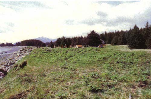
Figure 6. The site surface viewed from its north end.
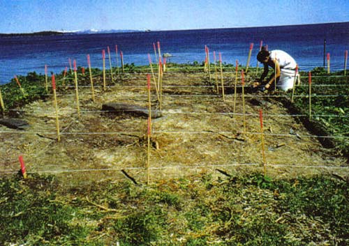
Figure 7. The excavation after removal of the turf layer 1999. Note large stone slabs at the top of the 1912 volcanic ash.
Larger and smaller cobbles and boulders make up the shore in front of the site. Minor outcrops of bedrock are dispersed among the boulders. A very low or minus tide uncovers a sandy bottom and bares numerous reefs that are home to many edible creatures. The shore is exposed to waves and weather from the east that come in across Marmot Bay, though the numerous outlying reefs and islets break the full impact of storms. The usual complement of intertidal invertebrates can be found on these rocks. We noted, in 1999, however, that the blue mussels around Afognak Bay are small. According to local knowledge there are razor clams in the sand in front of the site but we did not find their shells in the midden. Octopus is common at nearby Graveyard Point while Lipsett Point is a good locality for large chitons (gumboots). Whales sometimes come close to the shore between Lipsett Point and Afognak Strait.
Glacial till underlies the site. Findings elsewhere on Kodiak indicate that the land became free of Ice Age glaciers about 11,000 years ago. Eventually the edge of the sea approached its present limit and gravel was washed in from the beach over the outer edge of the site. A thick deposit of fine soil that is mainly volcanic in origin then formed over everything. Its presence shows that the site has been above sea level for at least the last 7000 years. Several volcanic ashes or tephras have been identified on Kodiak and Afognak and dated to that time (Tannenbaun 1996). The ash-derived soil at the base of the site probably is a composite of several falls. Much later, housepits were cut through the ash down to gravel. Eventually several feet of shell refuse, fire-cracked rock and stone structure slabs accumulated. Late in the site's history refuse of historic occupation was added. Then in 1912 a thick layer of Katmai volcanic ash (from the Novarupta vent but following local usage we designate this as the Katmai eruption and ash) blanketed the site. In places the ash was shoveled off and into low areas, making the surface more even than it had been in the last. Some deep depressions adjacent to houses also were filled in at this time with "bulldozed" volcanic ash and soil. Occupation, and also gardening in some areas, continued for another 48 years until about 1960, as represented by finds from the turf. Then the last occupied house was abandoned.
AFG-004 is the principal one of several sites located in the area extending from Graveyard Point to Lipsett Point. Others include the following sites:
AFG-005 at Lipsett Point, now has completely eroded away. In 1974 it was a 70-yard-long deposit primarily consisting of sweat bath rubble. It is attributed to the Koniag tradition.
AFG-003 is located across the creek that passes by the Aleut Town site. In 1964 1.5 to 2 ft thick deposits were seen in a 30 yard-long band at the eroding bank. Additional thin traces of habitation refuse extended for another 20 yards along the bank just below the Katmai ash. In 2000 traces of midden were still visible at the eroded bank which, however, was largely obscured because of slumping and vegetation. The area behind the bank is being cultivated for gardens. Traces of midden, stone slabs and late historic artifacts are exposed in the garden. The artifacts are primarily late ceramics.
Two exposed middens, as of 1964, designated as AFG-002 faced the shore in the bight immediately north of Graveyard Point. Deposits were about 24 inches thick. They are not visible today, but parts of the garden plots that were on the site remained visible in 2000.
Graveyard Point has a small, thin shell midden located within the cemetery that has been partially removed by erosion. Graves were reported eroding out at this location in 1984.
EXCAVATIONS
Grids of 1-meter-square sections were laid out by tape and transit on the central area of the site (Fig.8). The 1999 grid measured 4 by 5 meters, that in 2000 4 by 6 meters (less three sections not excavated). As well, a shallow 3m by 75-cm trench was excavated on a slope next to the creek to observe the depth and layering of deposits. Datum for the excavation is Cadastral Survey Monument S5698 that lies on the Lot 22 C1 and Lot 25 C4 property line. The need not to disturb this monument constrained us from excavating as far to the east as was needed to completely uncover a house floor. East-west orientation was set according to a line extending from the survey monument to a 4-ft-tall steel stake driven into the ground near the edge of the bank. It was our initial understanding that this stake was on the property line (as is the survey monument), and as the allotment boundary lines run-east-west, the two points should have defined a cardinal direction. It appears, however, that the iron stake is incidental and unrelated to property lines. The direction we took to define the dig layout probably runs close to 80 E, true, instead of 90 degrees.
The turf was removed and shook out to remove historic artifacts. Any brown soil remaining between the turf and Katmai was excavated. Then the Katmai ash was excavated. It was especially thick in some places but was thin, missing or thoroughly mixed with soil in most sections. The ash was trowled and a moderate number of artifacts was recovered from it, especially near its base. Among these are items lost when the ground became obscured that day in 1912 which in a sense represents a Pompeii effect.
Brown rocky soil of historic age was found below the ash in some sections. In many sections there was a mixed or secondary deposit of historic soil and artifacts, precontact soil, old fine midden and Katmai ash. This matrix extended in the northern sections of the 2000 excavation down to a gravel floor located about 30 cm below the surface, but elsewhere it extended to about 65 cm depth or was the fill of a large feature pit and infilled depression that extended to the base of the site. The gravel floor was a living surface. Two banya features are associated with this surface. Except for the feature pits, little historic material occurred at any greater depth.
Level control in 1999 was by means of one line level station and in 2000, to avoid problems we had the preceding year, three line level stations referred to a subdatum, which in turn was referred to the site datum. Noteworthy artifacts were point plotted by depth, east and south position within each one-meter section. Prosaic items were put in
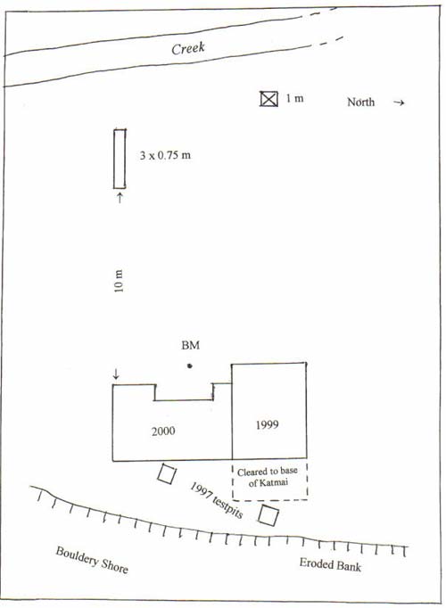
Figure 8. Layout of the excavations in 1999 and 2000. Grid units are one meter square.
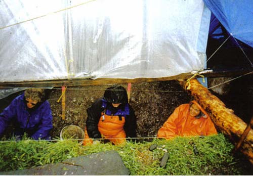
Figure 9. Guests and staff excavating in 1999. The weatherport covered only half the excavation. A log across the top of the excavation supported one end of the structure.
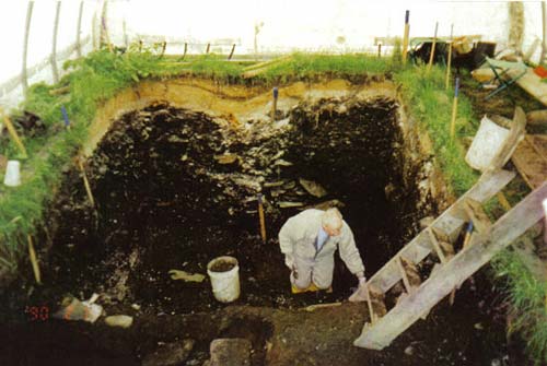
Figure 10. A guest from New Yorkexcavating at the base of the site in 2000.
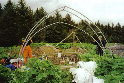
Figure 11. Erecting the weatherport over the dig in 2000.
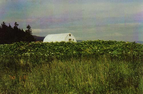
Figure 12. The mediator between the excavators and the elements.
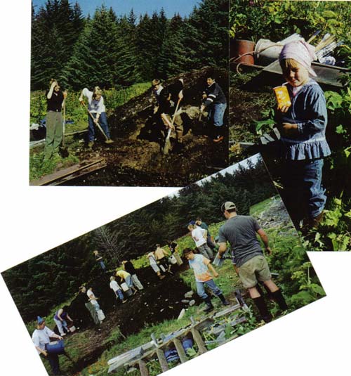
Figure 13. Filling in the excavation laboriously created with trowels in 2000.
level or lot bags along with faunal remains. In 1999 the level bags were turf, Katmai, 0 to 10 cm below Katmai, the next 10-cm level, then a series of 15-cm levels. We started measuring for levels from the surface in each section but it soon became evident that with increased depth the original surface ceased to have much relevance. In fact, it had created steps between same-numbered levels of various sections, so we switched to using universal or single levels covering the whole excavation. As well, it had become necessary to remove most meter-section corner stakes because of the interference of large stone slabs, and their removal created further problems for recording. A few buckets of dirt from the upper, historic, deposits were wet screened on fine mesh in 1999. Contrary to expectations this yielded no trade beads and it became evident that the historic layer was very shallow (which was not the case for the 2000 excavation). The next year many buckets of dirt were processed dry on quarter inch mesh, but no small objects were recovered on the screen from below the historic zone. Probably some small objects were lost by not processing all deposits with one-eighth inch screens, but that procedure would have been impractical.
A small excavation measuring 0.75 by 3 m was made near the stream bank. It was done to test the proposition that the steep slope at the stream bank is unnatural and that the top of the site had been "bulldozed" in that direction creating a level top adjacent to a steep slope. As well, it was surmised that the soil test might reveal a history of "landscaping" that would account for the lack of Koniag phase and Russian deposits. Results showed this hypothesis to be completely wrong and the deposits to be undisturbed though thin at the location tested. The mounding was due to a high natural deposit of substrate material.
SOILS AND STRATIGRAPHY
A thin but competent layer of turf caps the site. It incorporates living surfaces postdating 1912 and settings of houses that had persisted from earlier times. The volcanic ash layer of 1912 bears the imprint of later use of the site: gardening, clearing of ash from dwellings, caved sheds, and the infilling of depressions.
The Katmai ash thus has a variable presence. At the seaward edge of the area excavated in 1999 there was no ash. This area either was sheltered by a house in 1912 or it was carefully cleared off. But such cleaning does not appear to have penetrated deep enough to eliminate any precontact Alutiiq layers. In 2000 we found some thick Katmai ash but we also found complexities attributable to ash intermingled with collapsed porches and sheds and cleanup after the ash fall. One area had intermingled lenses of ash and historic deposits, and adjacent to it at the top of the deposits there was evidence of spading (rounded spade dips in gray soil penetrating tan Katmai; Fig. 20), probably for a garden. Elsewhere in the 2000 excavation, two pits that originally penetrated to the base of the site had been filled in. One pit contained a decayed wooden barrel; the other had a sand floor. Both were in the process of being filled with refuse from sometime before the 1912 eruption and filling continued after the eruption judging from lenses and small amounts of Katmai ash in the upper fill levels. The fill consisted not only of historic soils but also of some of the old precontact deposit. Thus, historic artifacts and items possibly more than 1000 years old were intermingled. (A test pit dug in 1997 by Woodhouse-Beyer next to Section I immediately outside the 2000 excavation appears also to have encountered a secondary fill of mixed age.) This evidence shows that there had been deep depressions on the site, either surviving from precontact occupation or dug by early historic (American period?) occupants that were filled in early in the 20th century, and that there had been "landscaping" and gardening of parts of the surface. But part of the area excavated in 1999 had large stone slabs near the surface. It is evident that there had been no gardens there and if there had been any surface clearing it was followed by later stone placements. Significantly the fill deposits did not contain late precontact Alutiiq (Koniag) artifacts. Instead, the matrix where displaced was late historic or a mix of late historic and Kachemak pre-Koniag deposits. There was no evidence of upper layers being shoveled over the bank to level the site, but at the ocean face such evidence would have been removed by erosion, thus this observation may be valid for the back, stream, edge of the site only. In sum, we found no evidence of substantive Koniag and Russian period (early historic Alutiiq) occupation of the area excavated in 1999 and 2000.
Varying dark-brown stony soil appeared below the Katmai ash. In some sections this soil contained midden particles-mainly shell-and many pieces of fire-cracked rock. This layer is historic. It includes historically disturbed or mixed deposits in which the matrix was dug up from earlier layers. Numerous stone slabs and blocks were found at various levels. Some had been dumped in with historic disturbed material, others evidently were parts of features, as described later. Some stones were of substantial size, over one meter long and weighing over 100 pounds. Stony dark brown to dark gray soil layers with varying amounts of admixed shell continued into deeper parts of the site.
Thick crushed midden bands composed mainly of blue mussel shells, and whole butter clams locally, were prominent in the lower deposits. In places the midden became differentiated into bands of varying purity, mixed with soil and stone. Through removal of the midden fill two steep-sided rectangular depressions were reveled. These are house pits, described in the next section.
At the base of the series of midden layers thee was a layer of rocky brown soil both within and outside the house pits. These deposits were underlain by fine volcanic soil often termed "butter clay" following Hrdlicka's (1944) usage.
FEATURES
North House
Parts of two semisubterranean houses were uncovered. The North house was partially excavated in 1999 and further excavated in 2000 though a portion near the survey monument remains unexcavated. The following description combines both seasons of excavation. The plan of this structure is shown in Figure 28. The pit plunged steeply through the light brown soil (butter clay) found at the base of the site. This soil
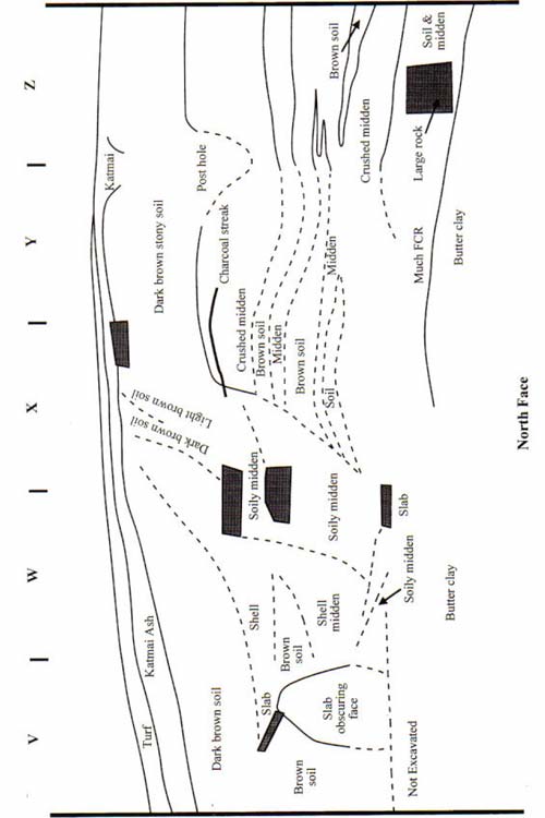
Figure 14. Stratigraphic profile of the north wall, 1999. Vertical scale 2 x horizontal.
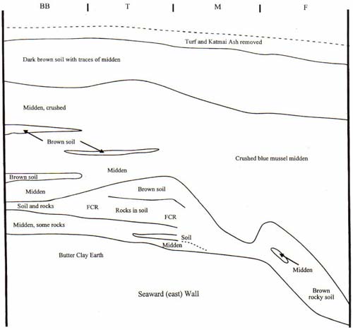
Figure 15. Stratigraphic profile of the east wall, 1999. Vertical scale 2 x horizontal.
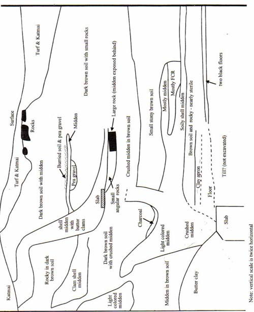
Figure 16. Stratigraphic profile of the south wall, 1999. Vertical scale 2 x horizontal.
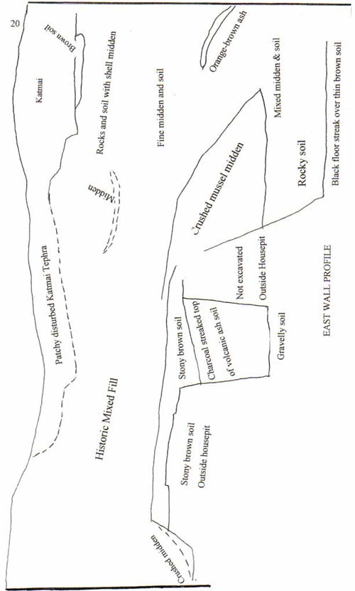
Figure 17. Stratigraphic profile of the east wall, 2000. Vertical scale 2 x horizontal.
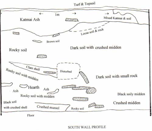
Figure 18. Stratigraphic profile of the south wall, 2000. Vertical scale 2 x horizontal.
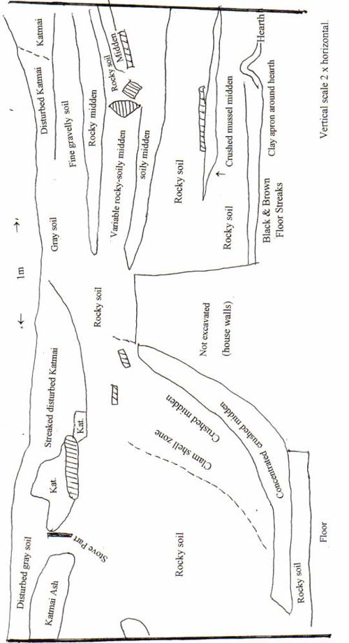
Figure 19. Stratigraphic profile of the east wall, 2000. Vertical scale 2 x horizontal.
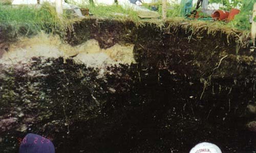
Figure 20. Clean Katmai ash and ash mixed with soil (dark gray) at the southwest corner of the 2000 excavation. Shovel scoops at base of the gray layer may be from gardening.
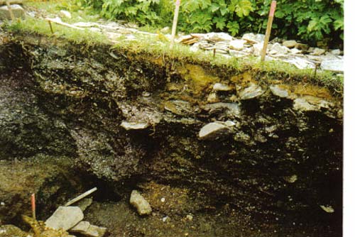
Figure 21. Pits and plunging midden fill at the 1999 south exposure of the North House pit fill further excavated in 2000. The "bench" is butter clay outside the house. The stone slabs no longer define a coherent feature.
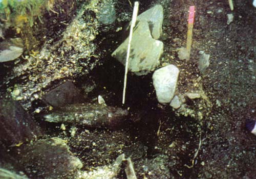
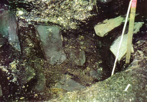
Figure 22. Slab and soil-lined pit in NW sector, 1999. Work has progressed deeper in the lower view. Most slabs in the upper view no longer are present in the lower photo.
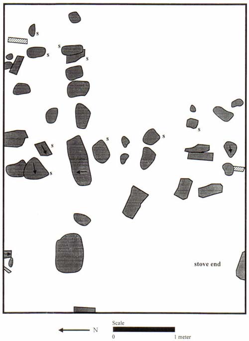
Figure 23. Stone slabs in the top level of Layer 3,1999. Some slabs lay exposed on the surface in 1912 and were covered with Katmai ash.
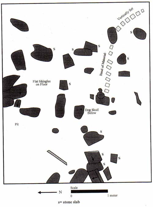
Figure 24. Stone slabs exposed in the second level of Layer 3, 1999 (20 cm below Katmai ash).
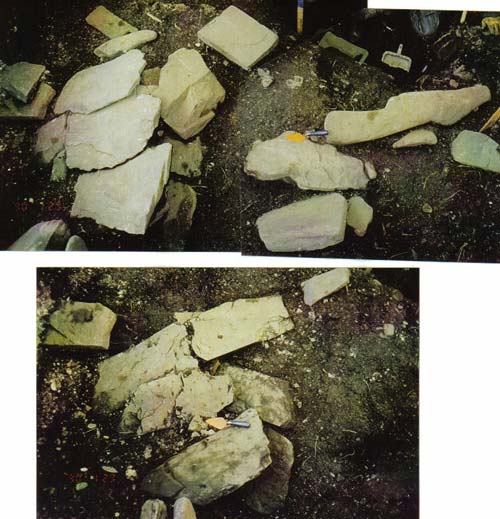
Figure 25. Stone feature uncovered in the 2000 excavation, upper and lower stones.
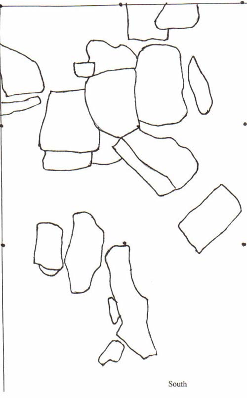
Figure 25. Drawing of stone feature uncovered in the 2000 excavation, upper stones
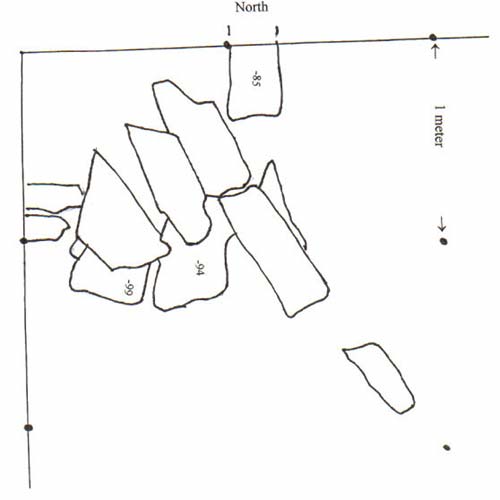
Figure 25. Stone feature uncovered in the 2000 excavation, lower stones
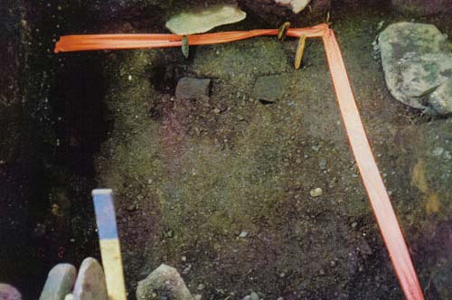
Figure 26. North house floor. The ribbon is on the east and south edge; remaining edges are in the wall. The dark chasm in foreground is a deep subfloor pit.
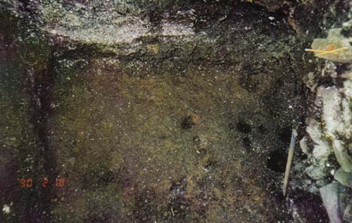
Figure 27. South house floor showing an area of postholes and the edge of the north wall to the left. Shell midden fill dips into the house pit.
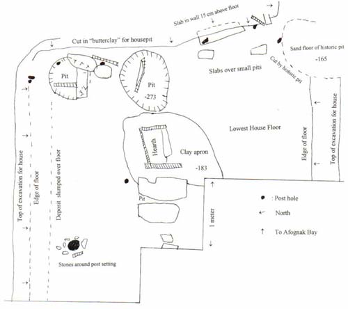
Figure 28. Drawing of North house floor.
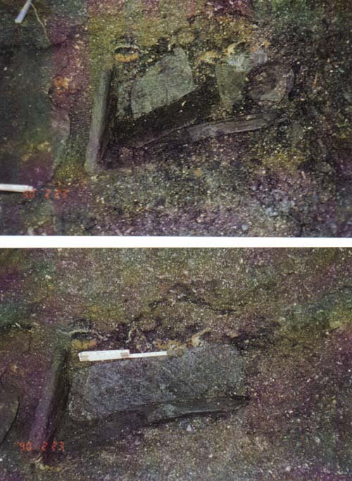
Figure 29. Stone slab hearth in the North house and two slabs that covered a subfloor depression.
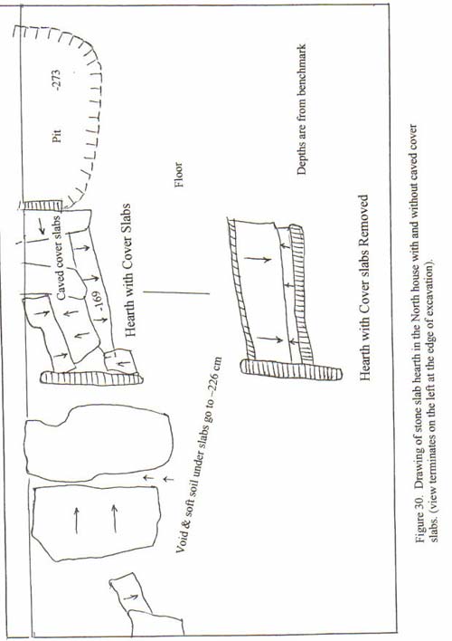
Figure 30. Drawing of North house hearth.
(continued from page 16) was exposed in the north and south walls where the pit had cut into it. A relatively thick layer of hard-packed brown soil with minor amounts of admixed shell, bone and fire-cracked rock was encountered deep in the house pit. It was surmised that this was a floor deposit. It was almost sterile and was reluctantly excavated. But well-defined thin floor streaks subsequently were found below the packed brown soil. There were two floor streaks, and over part of the area a third streak, each hardly 1 cm thick separated by 1 to 4 cm of compact. brown soil. The floor streaks extended over the entire house pit. Floors consisted of dark stains, with much charcoal near a clay apron around a hearth, and bits of fish bone and other material. Below the upper floor were localized orange-brown smears, which may be from rotted grass. There also was thin orange brown soil below the lowest floor, which may be of the same derivation or may be a trace of volcanic soil that did not get removed when the housepit was excavated.
Several postholes were found in clearing the soil and floor streaks. They extended well below floor level and in two cases were surrounded by cobbles, which may have been placed to steady posts during construction before stringers were attached. At the very east end there also was a pair of deep pits cut into the substrate, well below floor level. Single vertical stone slabs were found within each pit, and there were other slabs above the pits but these were not pit liners, and if they were covers they are disturbed. There was nothing especial to note inside the pits. Instead, there was soft, wet soil.. Immediately touching the edge of the largest, southern of the two pits, which was slightly elongate. was an elongate rectangular stone slab hearth. Two longitudinal slabs defined the sides of the hearth. Another slab closed its east end. Thinner slabs were aid over the top of the hearth. These may have formed a cooking surface. Immediately west of the hearth was another large roughly circular pit, not as deep though as the one at the east end. Two large slate slabs covered the pit. Underneath the slabs there was a void and loose soil but no pit lining and no noteworthy contents. Continuing west of that there were three small slabs that failed to form any orderly element of the feature. Two layers of semi-consolidated gritty clay formed an apron surrounding the hearth, to the north and south (the east and west vicinities were largely occupied by the pits). This layer, and we believe also the hearth, is correlated with the upper floor. An unmodified femur was found near the hearth. This was the only human bone found in the 2000 excavation. It was reburied in the structure.
A large stone lamp was found upside down resting on a sandy floor at 97 cm below datum in 2000 Section A0. Id was next to a deposit of hearth ash on the same floor. These features did not develop into any living surface clearly present beyond Section A0, though it is logical that a more extensive living surface had to be present. The 97 cm depth is well above the 144-154 depth to the upper floor of the North House.
South House
A large area of hearth deposits was found in the southeast corner of the excavation, encompassing all of 1-meter Section S0. There were a few stone slabs near the hearth, but none were in an or unlike the case with the North House where there were three well-developed floors. Again, there were almost no artifacts on the floor. For the four floors from the two houses there was on the average about two ulu blades or major fragments per floor.
Stone Slab-Lined Pit
This feature is characterized by use of stone slabs and blocks in its construction put portions of the surviving pit walls are soil The stone slabs and blocks started to appear by the time the 1999 excavation of had gone two levels (20cm) below the Katmai ash. As the excavation proceeded it became apparent too that the stones were embedded in a soil matrix that was part of the site's man-made deposit. The pit was revealed primarily through removing the shell midden that had been deposited within it. The clarity of its definition suffered from the fact that the north edge was just outside the archaeological excavation and the upper part of the western edge was cut by a burial pit (see below). The stones around the pit were sketched at one stage and removed only to reveal additional underlying slabs and blocks of stone (Fig. ). Near the base of the pit there was a large elongate angular stone and more, smaller, slabs. Finally, at the base of the pit 126 cm below datum and more than 100 cm below the top of this feature (perhaps originally deeper) we found a floor formed by one large and one smaller stone slab. There was only soil below the basal slabs. One side of the pit had been dug well into the volcanic soil substrate. We suspected or feared that this might be a burial pit but there was nothing inside indicating that. Nor was there anything at all of note such as fish bones, egg shells and animal bones that would indicate use as a food cache.
Burial
A flexed interment was found in the northwest corner of the 1999 excavation, two-thirds way to the base of the site in a shell layer. Sufficient bones were uncovered to determine that this was a burial and not just an isolated, scattered human bone. It was covered up without being photographed or anthropometric observations being taken, and blocked off from be rest of the excavation by stone slabs. This was practical and did not obstruct work elsewhere because of its location in a corner. Two large thin stone slabs located on either side of the burial may be part of a pit lining. They are 72 and 75 cm long (about 29 inches), one vertical, the other sloping inward towards the base at about a 45 degree angle. Additional smaller slabs supplemented them. It was common for ancestral Alutiiqs of the Koniag and Kachemak cultures to inter within their villages (as well as elsewhere). Thus, in a sense, the deceased remained a part of the community.
Solitary and Grouped Stone Slabs
Numerous stone slabs were encountered. Those found in 1999 were mainly in the upper levels and in part are historic (Fig. 23) while slabs were scattered throughout the 2000 excavation. Many slabs were not clearly linked with other slabs, e.g., they were isolated occurrences, and where slabs did occur in clusters they failed to define functionally identifiable features. Examples are illustrated. The grouping in Figure had two layers: an upper layer of closely set thin slabs and a lower layer of large stone blocks. There was nothing in particular to note below the slabs. The slabs probably are part of house and grounds features, like storage pits, that had become disturbed or disarranged after the features went out of use.
Isolated human bones were found on ten occasions in 1999 but only twice in 2000. These remains were reburied at the base of the site. Such occurrences are numerous in Kachemak sites. In some cases they are the result of disturbance and scattering of burials during the excavation of pits for sunken houses and for in-ground caches, but bones with cut marks and modifications such as drilled holes suggest that postmortem rituals with human remains and violence also are involved.
Pea Gravel Floor
Pea gravel was found at the south edge of the 1999 excavation in or at the base of a small rectangular wood slab enclosure. The gravel was found only 30 cm below the pre-Katmai surface. Two sides were recovered and it was thought that the remaining sides of a rectangular enclosure lay in unexcavated ground. The wood was very decayed, but it was sufficiently intact to determine that the grain was oriented vertically. The feature was thought to be historic. In 2000 the remaining sides of this feature were not recognized but there was a widespread peagravel and sand layer (mixed with dirt) at a concordant elevation that formed a historic floor in the north half of the excavation. Moreover, in the meter square of 2000 that would join the 1999 section with this feature there was a ring of disintegrating rusty iron, as might be expected from a large tub, and some fire-cracked rock, all of which might have been part of a banya. Two meters farther south concordant with or set on the sandy floor there was a hearth, outlined by slabs on three sides and a few additional chunks of fire-cracked rock. This appears to be a banya as constructed before stoves fashioned from oil drums came into use to heat the rock.
Petroglyphs
The Aleut Town petroglyphs are located on a ledge of graywacke that juts out from the shore about 350 yards northeast of the site. They appear in a small panel of
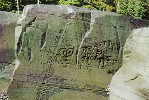
Figure 31. Afognak petroglyphs north of Aleut Town.
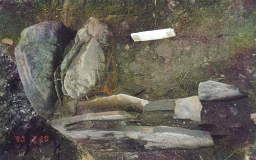
Figure 32. Historic banya hearth. The tallest rock slab protruded through the Katmai ash above the surface of the site. But the feature was set into the ash.
faces and one possible whale figure on a vertical seaward-facing surface (Clark 1970) (Fig. 31). The faces are portrayed with labrets. Labrets have a time depth of little more than 3000 years on Kodiak. The petroglyphs also show lines extending downward from the eyes and this feature is found in historic and late-prehistoric specimens, as from Karluk, and suggests that the age of the figures is considerably less than 3000 years. These figures are published and have been popularized in products of the Alutiiq Museum and the Afognak Native Corporation.
COLLECTIONS
INDIGENOUS-TYPE ARTIFACTS
The artifacts can be sorted into functional groups such as (a) hunting and fishing including weapons (b) transportation, mainly boats, (c) household items such as lamps and bentwood containers, (d) tools including fabricators used to make other tools, (e) clothing and accessories and personal adornment, (f) ceremonial, ritual and games, and also (g) architecture meaning houses, caches, etc. (Table 1). By frequency, the tool category predominates, but most tools are rudimentary, like hammer stones and handy multiple task cobble spalls. The distinctive character of each of the three traditions or cultures on Kodiak depends very much on styles of hunting implements and on a limited number of other artifacts such as distinctively sculptured Kachemak stone lamps and labrets. To a lesser degree the traditions are distinguished by the presence or absence of certain technologies and artifact types such as heavy grooved Koniag splitting adzes and the Koniag penchant for pottery (except on northeastern Kodiak and Afognak Island).
The terms used for arms and weapons - spears, lances, harpoons, darts, leisters, arrows - can be confusing. A spear leaves the hand, i.e., it is thrown and does not have a line attached to the head. If the spear has a fletched shaft it may be called a dart. Some darts are only slightly larger than arrows that are shot from a bow. Whales were killed with long darts. An implement that is held and thrust is a lance. Lances tend to be heavier than spears. With a harpoon, a connection is maintained with the struck animal by means of a line attached to the harpoon head. Harpoons can be cast like spears, thrust like a lance or shot from a bow as in the case of the harpoon-arrows used for hunting sea otters. Leisters are spears and darts with multiple prongs or tips used for birds and fish.
TABLE 1: LIST OF ARTIFACT CLASSES AND TYPES
(2000 Season), [1999 Season], Total
______________________________________________
Hunting and Arms
Ground slate projectile tips (9) (4 complete; 5 damaged, fragment or unfinished), [8], 17
Flaked chert spear head [1]. 1
Bone lance blade? (1) (symmetrical bipointed) 1
Bone arrowhead (8) (5 slender barbed points, 3 other), [5, all but 1 frags], 13
Spear side prong (1) (base fragment), [1], 2
Elongate spear prong? (1) (long base-stem fragment), 1], 2
Harpoon arrow socket piece (called foreshaft) (2) (historic, 1 a fragment), [1], 3
Harpoon arrow head (barbed tip) (1) (historic), 1
Harpoon socket (2) (1 small, 1 large lacking diagnostic ends), [6 probable], 8
Foreshaft for toggle harpoon head (2, or 3 in 2 varieties), 3
Harpoon heads (15 complete or major fragments), [17+8 fragments], 40
Miniature harpoon heads [2], 2
Base fragments, shouldered harpoon base format) (6), 6
Unbarbed point, base like harpoon head [6], 6
Toggle harpoon heads (9) (2 are fragments), 9
Throwing board peg (1) & shim or possible throwing board peg of a different format (1), 1
Heavy barbed bone spear heads (3,1 is cleft for an endblade), 3
Unclassified unilateral ly barbed points (arrow heads and spear prongs) (8 + 3 small fragments), 11
Fishing Group
Grooved stone (weight, short grooves over sides & one end, over ends) (2), [1], 3
Compound hook, shank part [2], 2
Compound hook barbed part (3), [5], 8
Gorge (bone prong pointed at both ends)(l?, asymmetrical), 1
Gorge (bone splinter sharpened at both ends) [1], 1
Food Gathering
Digger tip, bone (5) (for roots and/or clams), [1], 6
Stone Fabricators and Stone Implements
Adze hafts, bone (2), 2
Adze bits [2, 1 at erosion face looks Koniag], 2
Hammerstone (utilized pebble/cobble) (8) , [11 = some nc], 19
Chopper on cobble edge [1], 1
Stone slab scraper & ulu-shaped scraper (hide scraper) (8), [11], 19
Cobble spall (boulder flake) (11), [31]. 42
Pumice and scoria abraders (11) (mostly red pumice), [18],
Large bar-shaped whetstone [2], 2
Tabular hone (5), [2],7
Pebble lump hone (1),
Large, irregular stone block whetstone (1), 1
Slate whetstone of pencil format (1), [1], 2
Small slate sheet smoothed on flat edge [1], 1
Burnisher smoothed on flat edge (1), 1
Smoothed and sharpened tonalite pebble shingle [1], 1
Small double-edged ground slate knife (1), 1
Double-edged ground slate ulus or flensing knives (2 fragments), [2 frag.; 1 has 4 drilled holes], 4
Ulu blade with drilled hole (7), [3], 10
Other ulu blades including minor fragments (44), [45], 89
Saws (10, may be ulu-shaped scraper, identification uncertain), 10
Flaked slate blade (blank for double-edged knife or lance?) (2), [?], 2
Pointed chert uniface, gouge or combination tool (1), 1
Red chert flake (1 detrital, + 2 tiny flakes not cataloged),
Roughly flaked leafshaped biface of greenstone [1], 1
Bone Fabricators and Implements
Wedges, tanged (3), [3], 6
Wedges, other and major fragments excluding blanks (68), [64], 132
Chisel or miniature wedge (4), [1], 5
Beaver tooth for tool bit [1], 1
Needle (1), [1] (broken, lack eye), 2
Birdbone from which blank strips have been cut off (1),[1], 2
Blank of bird bone (mainly blanks for needles) (4), [2], 6
Bird bone awl, whole bone shaft (11), [16], 28
Bird bone cut out strip or splinter awl (6), [include elsewhere], 6
Awl of mammal bone (3), 3
Large, flat bluntly pointed bone [1], 1
Household
Stone lamp (1), [1 water-rolled] 2 Large lamp weighs 32 lbs.
Ulu blades (see Stone Fabricators and Implements)
Pot fashioned from whale vertebra [1], 1
Decorative, Personal Adornment, Play and Possible Ritual Objects
Carved pin (1, very long), [3 different], 4
Nose ring (3) (1 small jet, 2 red stone), 3
Nose pin or gorge [1, #888], 1
Nose pin [2], 2
Labret (1), [4], 5
Historic ornamented object (1) (historic, walrus ivory, from Bristol Bay north?), 1
Ornamental objects [3], 3
Miniature walrus mask [1], 1
Pendant bead (1) (made from tooth), 1
Bone tube bead (2) (with decorative lines); Bone tubes (2), [3], 7
Jet bead (1), 1
Modified halibut vertebra ring (1 frag.), [4], 5
Rock oyster shell [1], 1
Incised pebble (1) (clothing design, no face), [2], 3
Small grooved bone sphere [1], 1
Bear molar, small (1) [1]; Canine large grooved (1); Seal canine grooved (1), 4
Unique longitudinal tooth section [1]. 1
Small pebble spheres and disc (4), 4
Eagle claw bone core (2) (left in faunal bag), [1], 3
Red chert pebble and flaked piece, water rolled (3), 3
Yellow chert flake [1}, 1
Slate pebble with incised circle (1), 1
Incised slate rod, historic?, (1), 1
"Glitter" (hematite?) mineral (1), 1
Unfinished and fragmentary jet objects (4, unfinished spherical bead?.
Three discoidal objects with large central perforation), [4], 8
Miscellaneous
Sawn & cut whale, other mammal and bird bone (many left in level lots)
Shaped bone not a recognized implement (unfinished, preform, eroded or
Fragment) (8), [10], 18
Heavy bone shaft, frag. [1], 1 See also socket pieces and digger tip.
Unidentified finished bone object (4)(1482, 1508, 1539, 1698), [3], 7
Delicate, slender sharply pointed slate pin (1), [1], 2
Bone fashioned to a tip or point (1), [4], 5
Ground slate rods, most tapered, some may be a type of point (5), 5
Fractured quartz pebble [1], 1
Resin, small lump [1], 1
_______________________________________________________________
Selected historic manufactured objects recovered in 2000 and all those found in 1999 were catalogued. These number approximately 700 items. The remaining historic manufactures in the 2000 bag lots amounting to about 2300 items were inventoried (Appendix II). The following list incorporates both groups for 2000. Because of the mixing or disturbance of deposits in some areas excavated in 2000 the number of objects unequivocally assigned to a pre-Katmai provenience is smaller than the number that probably originated from that context. As the provenience data for 1999 are subject to less ambiguity, and may reflect differing details of site use we have prepared separate tallies for the two seasons.
Figure 33. Slender slate bar with incised decoration.
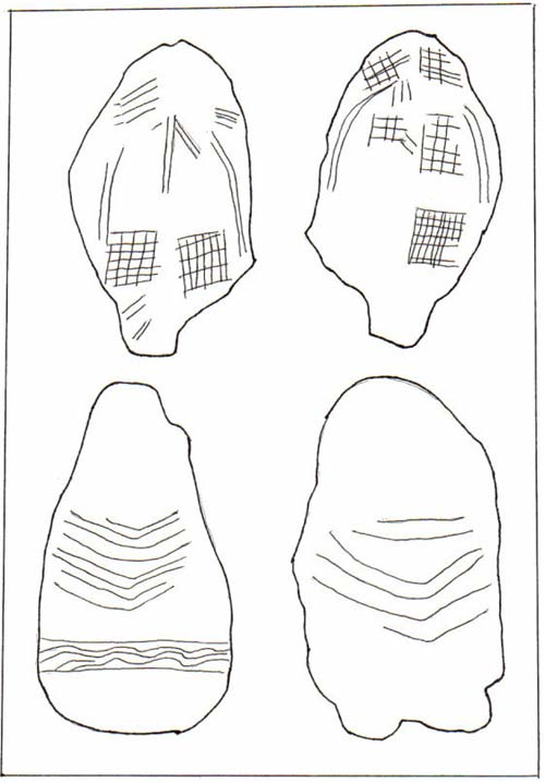
Figure 34. Pebbles with incised figures.
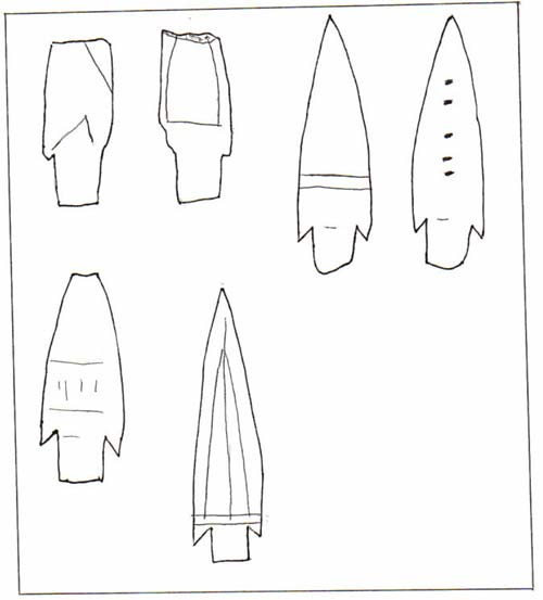
Figure 35. Marks on slate spearheads.
Net use then reflects local activity and provides clues to what activities were (or were not) undertaken at Aleut Town. These differences are not of broader cultural significance as Aleut Town people simply caught their salmon a few miles away. Previously at least a modest number of small notched pebbles had been found at sites where salmon netting is not a likely occupation, at Three Saints and Monashka Bay for instance. The contrast or correlation between artifacts and occupations was not as clear as it is now at the Aleut Town site.
Not only are net sinkers lacking , but other fishing gear also is scarce which is more difficult to explain considering that fish bones are common in the site. Here we refer to the absence of fishing lures, fewness of probable fish spear prongs, fewness of fish hook parts and of gorge-type hooks, and the scarcity of notched and grooved cobbles for weighting lines to fish in the sea. One cobble weight, with three short grooves is a common Koniag type and came from the shallow trench at the side of the creek, and another one also was recovered from a shallow depth..
To find out whether the Crag Point-Aleut Town artifact configuration has any significance as an area variation of the Kachemak tradition, it is necessary to examine assemblages from sites located elsewhere on Kodiak, particularly the Uyak site on western Kodiak and Three Saints. Three Saints is a relatively small collection that suffers from limited organic preservation. On that basis there appears to be no salient reason for regarding Kachemak culture around Marmot Bay as being significantly different from its contemporaries elsewhere on Kodiak and Afognak. One difference though, that may turn out to be significant, is the scarcity at the Aleut Town site of double-edged elongate ground slate knives of a dagger or man's knife format. There is only one small specimen, with rounded end. It might be compared with a butter knife. In contrast, there are seven knives from Crag Point and 36 specimens plus possible fragments from Three Saints (Clark 1970 Table III. As well, in one Late Kachemak area or barrio of the Uyak site, excavated subsequent to Hrdlicka's work there, flaked stone, largely basalt, was a prominent industry (Steffian 1992). These collections are in the same order of size when notched pebbles (very numerous at Crag Point) are excluded. Another difference or contrast, seen between Crag Point and AFG-004 is the reduced frequency of sewing tools, especially needles, at the latter.
Further Descriptive Notes and Comments
Comments on certain artifacts, including differences between the Kachemak and Koniag traditions are given below.
Red shale beads are common in Kachemak tradition sites, especially at Crag Point and at Kachemak Bay. They were expected at AFG-004 especially inasmuch as people there and at Crag Point both used the same stone for nose rings. In part, their absence may be a consequence of inadequate screening. The red stone is thought to have been traded from Kachemak Bay. Beaver and porcupine teeth also were imported from the mainland, for carving tool bits. A single specimen was recovered (Plate ) which is fewer than expected. Other imported materials, mainly derived from the Alaska Peninsula, include the coal used for jet labrets, and antler. Antler does not appear to be common.
Wedges are proportionately more numerous at the Aleut Town site than at other sites in the region, where, nevertheless they also are common. The following figures compare their numbers in relation to the recovery of two categories of weapons: at three other sites (percentages based on the total of three artifact types).
TABLE 5: RECOVERY OF BONE WEDGES AT FOUR SITES
|
Type A
|
Type B
|
Type C
|
||
|
(below are subtypes of barbed heads) |
||||
|
With
|
With
|
With
|
With
|
With
|
|
LINE HOLE
|
SHOULDERED BASE
|
LUGS ABOVE BASE
|
COMBINATION
|
NOT CHES
|
|
Type A1
|
Type A2
|
Type A3
|
Type A4
|
Type A5
|
|
|
|
|
||
|
UNILATERALLY
BARBED A1a |
UNILATERALLY
BARBED A1b |
Similarly, unilaterally and bilaterally barbed
subtypes for other varieties: A2a, A2b etc. |
||
Type B may not be a true harpoon as it neither toggles nor has barbs to hold. Some archaeologists have identified such specimens as foreshaft pins for toggle heads, but many of the present specimens appear to be too sharp for this function.
PLATE 1: LARGE HISTORIC OBJECTS. Bottle AM330:1142, below Katmai; hand forged iron lance 732; bottle 732, MURRAY & LANMAN DRUGGISTS NEW-YORK.
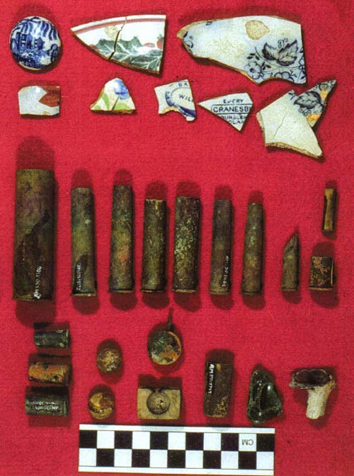
PLATE 2: SMALL HISTORIC OBJECTS. Row 1 (L to R): ceramic knob AM330:1515; 3 painted sherds 1706,1241,1624+1630; Baker & Co. Primrose pattern print 1522 & 1389; sherd, Empry hallmark 446A, sherd BA[KER & CO] WILL[OW] hallmark. Row 2: brass case for 10 ga shotgun 1306; 45-90 case 1372; 45-82 case 1524; 45-70 case thin head, shorter than preceding; 45-70 case USG; 22 hornet case? 1245; cut-off 45 case 1607; 30-30 case 1337; Western 25-20 case. Row 3: US pistol case1354; 44 rimfire case 1204; 44 rimfire cartridge with hole in side 729; musket balls 1747; pinfire cartridge head 1149; ball mold 1207; copper jacket 1349; beach glass 1355; kaolin pipe fragment 1151.

PLATE 3: HARPOON HEADS. Top row: toggle heads, L to R 551, 1135,1469, 1049, 1040, --, 1549. Middle: barbed harpoon heads, L to R 1529, 1098, 1556, 1510, --, 1059. Bottom: heavy barbed spear head 1016; spear prong 1119; stem of spear prong 1053; harpoon head; spear prong on birdbone splinter 1040, same 1523; fishhook barb?1126.
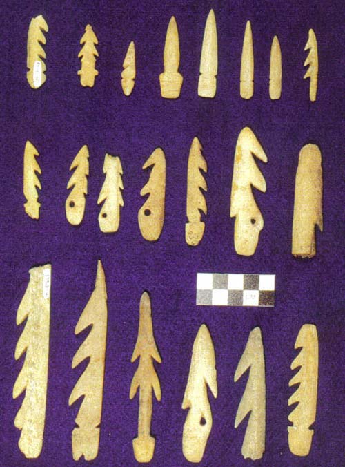
PLATE 4: HARPOON HEADS. Top row L to R: Harpoon head AM330:801, harpoon head 656, harpoon head 642, unbarbed point 624, unbarbed point 762, unbarbed point 586, barbed point 646; Middle Row: harpoon heads L to R 676, 626, 648, in Koniag style 656, 655, 786, spear fragment with blade slit 436; Bottom row: harpoon heads L to R 622, 641, 987, 910, 947, 647.
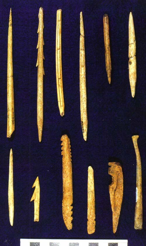
PLATE 5: SLENDER POINTS AND OTHER OBJECTS. Top row: prong 572; barbed arrowhead 1059; arrowhead with barbed ridge1560; arrowhead with barbed ridge 1059; same, fragment 1683; unbarbed point 1674. Bottom: bone gorge? 1638; barb1041; spear side-prong 925; toggle harpoon foreshaft 1119; trap trigger 506 (historic); baculum 841.
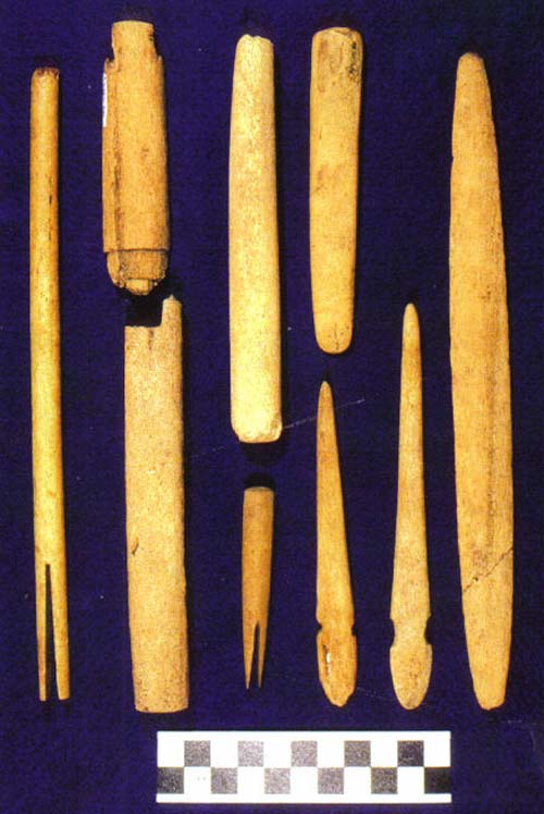
PLATE 6: SOCKET PIECES AND OTHER OBJECTS. Left Sea otter harpoon arrow foreshaft (with socket for tip) (historic). Second from left socket piece 746; long harpoon socket. Middle Long harpoon socket (ends incomplete) 1511; small harpoon socket 1045. Second from right tool with blunt tapered lower end 1204; toggle harpoon foreshafts 1012 and 746. Right Lance-shaped blade1607.
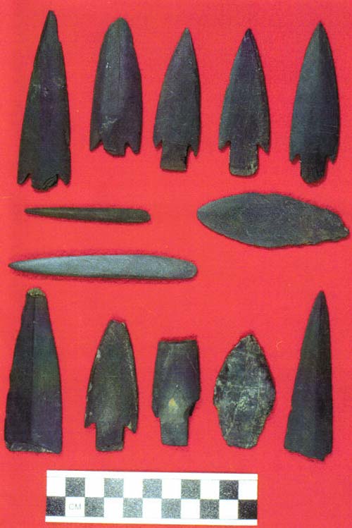
PLATE 7: LATE POINTS AND OTHER OBJECTS. Top row: Barbed slate points AM330:606, 606 (# dupl.), 1037, 1038, 1036. Middle: very slender point, base missing 1099; slate "awl" wedge base, not a whetstone 1553; knife 1546. Bottom row: large slate point, base missing 824; barbed slate point 608; decorated barbed (damaged) slate point 629; flaked chert spear head 752; fine slate point fragment 1134.
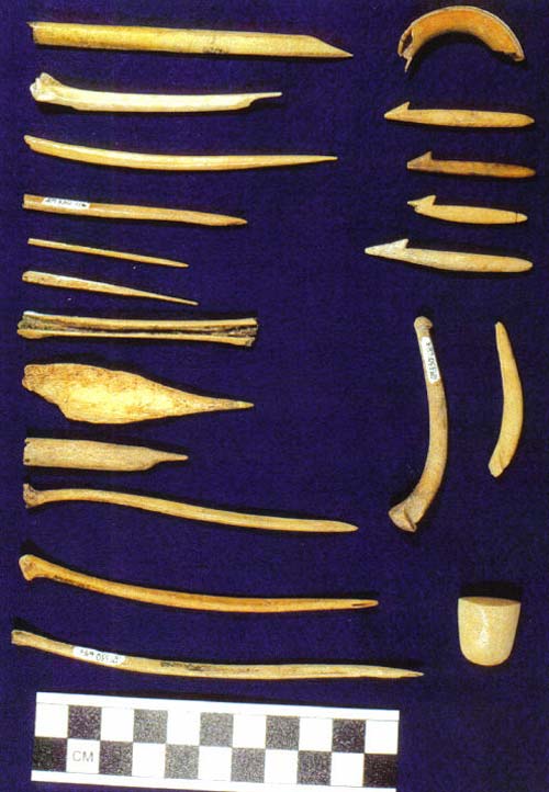
PLATE 8: AWLS, NEEDLE, and FISHHOOKS. Left column: birdbone awls 1456, 1512, 751; needle (eyed end missing) 604; pointed sawn birdbone strip 1087; bird bone with strip for needle blanks cut out 941; awl on mammal bone chip 1623; mammal bone awl 1427; birdbone awls 756,1163, 649. Right side: beaver tooth gouge bit 864; fish-hook barbs 630, 917, 915, 1519; fishhook shanks 638, 856; kayak joint bearing? 704.
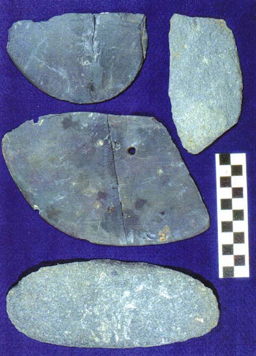
PLATE 9: ULU BLADES AND COBBLE SPALL. Complete ulu blade 1616; coarse stone scraper or saw 1576; large incomplete ulu 1452; graywacke cobble spall 1088.
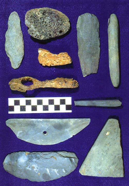
PLATE 10: VARIOUS TOOLS. Top area: roughly flaked blade 581; scoria abrader 509; red pumice abrader 1295; flaked slate blade, edges of stem ground 638; beach rod whetstone 1657; cartridge reloading tool (historic). Bottom area: fragmentary pencil-shaped whetstone 1641; ulu blade 621; thick ulu blade 1076; fine tabular hone 1077.
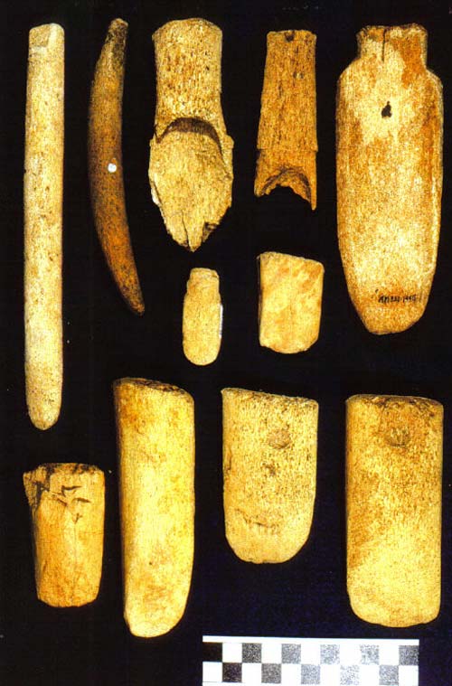
PLATE 11: LARGE BONE TOOLS. Top Row: Tips for digging tools 591, 1594; adze hafts 1019, 1604; stemmed wedge 1446. Center: small stemmed wedge or chisel 685; wedge 654. Bottom row: whalebone wedges 1137, 1081, 937, 1506, last two have pits.
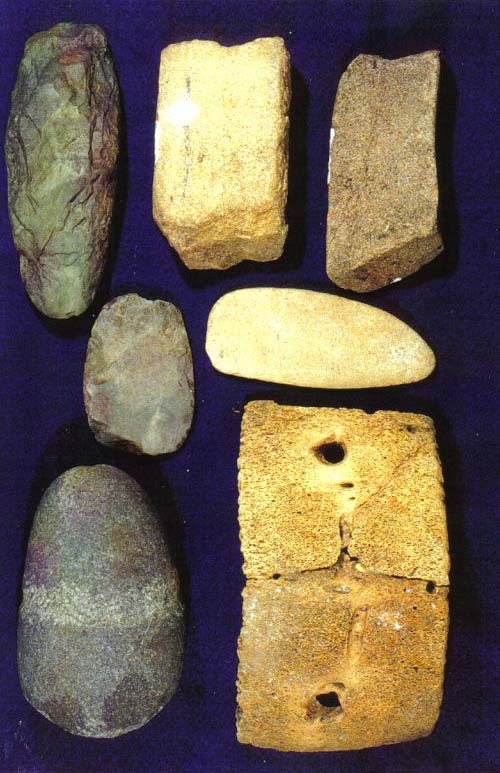
PLATE 12: HEAVY STONE TOOLS. Top row: adze bit from erosion face (Koniag?) 1003; sandstone block abrader worn on two faces 958; large abrader worn on three sides 957. Middle: adze bit (edge down) 271; tonalite pebble ground smooth and to an edge 903. Bottom: grooved maul 949; whale vertebra pot fragment 820, 840, 880.
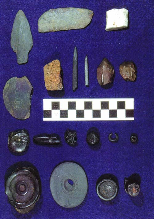
PLATE 13. STONE ORNAMENTS AND OTHER OBJECTS
First row: ground slate point (Koniag?) 605; small coarse stone scraper or saw 1305; burnisher (lower edge smoothed) 1000.
Second row: slate chip with incised concentric circles1133; red pumice abrader 1528, sharply pointed ground slate pin fragment 1360; small pointed ground slate bar 713, incomplete 713; flaked chert uniface tool 1112; beach-rolled red chert artifact.
Third row: unfinishd jet object with central hole 1561; fragment of jet ornament 659; jet ornament fragment with central hole; unfinished jet sphere 1311; small jet nose ring 1129; jet bead 1592.
Fourth row: jet labret 1536; stone labret 689; jet labret 55; jet labret 587; the last two with inlaid red ocher, buccal-side flanges damaged and reduced on all specimens.
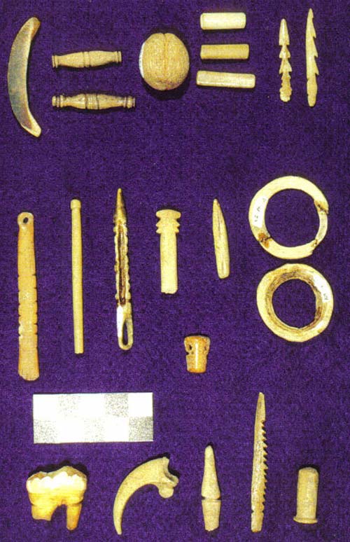
PLATE 14: JEWELRY AND CHARMS. Top row (L to R): Item cut from tooth AM330:1006; 2 "nosepins" 589, 607; grooved bone ball 691; 3 bone tube beads 682-657-741; miniature harpoon heads 923, 651. Second row: doll arm? 750; pin (end missing) 929; ornament? 792; head of pin (end missing) 788; pendant bead; halibut vertebra discs 787-783; miniature mask (walrus?). Bottom row: bear molar; eagle claw core J.L6; grooved pin (broken) 888; miniature spear 939; labret 689.
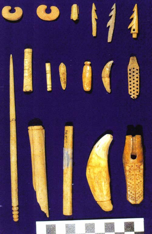
PLATE 15: DECORATIVE OBJECTS AND OTHER SMALL ITEMS. Top Row:
nose rings 1521,1325; throwing board peg 1516; barbed prongs 1047, 1092; harpoon- arrow head (historic)1562. Middle row: bone tube beads 1552, 1148; unidentified 1649; tooth pendant 1226; grooved tooth 1524; fragmentary item1225. Bottom row: pin 1152; birdbone tubes 1145, 1697; grooved tooth 1504; walrus ivory object (historic) 1064.
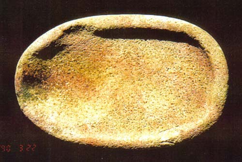
PLATE 16: LARGE STONE LAMP


© Copyright 2018 Native Village of Afognak ~ all rights reserved